Loading Images
Please bear with us...
Information
The prioritisation of retail over heritage in the 20th-century and the decline of the traditional High Street in the 21st has left upper Eastgate Street poorer in both.
Eastgate Street is one of the four cardinal streets of Gloucester, first laid down by the Romans when they established a fort in the 1st century on the site of the future city.
The Roman defences were rebuilt following the Norman Conquest of 1066, and in the mid-13th century the east gate was rebuilt into a substantial bastioned structure. In the late Middle Ages the east gate was one of the five official entrances to Gloucester, manned by porters and at which tolls were collected. It accommodated a prison in 1485 which, in 1560, housed female prisoners and, from 1613, was used as the bridewell (house of correction). During the siege of Gloucester in 1643, the main Royalist engineering effort was engaged in mining operations against the east gate.
Until 1275 Eastgate Street was the Jewish quarter and known as Jews or Jewry Street. The name Eastgate Street appears in the records in 1473, though the name Ailesgate Street is also mentioned in 1330 and 1709. Initially the least favoured of the four gates, Eastgate Street became established as an important commercial route in the early-16th century following the development of the Stroud Valley cloth industry. As a result, the parish of St. Michael, to which the street belonged, became one of the wealthiest, second only to St. Nicholas on Westgate Street.
The Church of St. Michael had been built on The Cross, where the four gate streets meet, by the mid-12th century. There is evidence to suggest the church was rebuilt in the 14th century, and the tower was added between 1455 and 1472.
A barley market that once stood close to the east gate was in 1655 replaced by a new market building in the middle of the street, half-way between gate and The Cross, and in 1737 country gardeners were allocated space on the street to sell their produce. In 1666 Sir Thomas Rich donated a house on Eastgate Street for use as the school that took his name (and was also known as the Bluecoat Hospital).
In the 18th century Gloucester enjoyed a brief period as a social centre for county gentry, and the Crawley-Boevey family of Flaxley maintained an old gabled house on Eastgate Street. The city's hostelries profited from its popularity, and by the 1720s the Saracen's Head on Eastgate Street boasted stabling for sixty horses.
Prompted by an increase in wheeled transport, obstacles to traffic were removed from the gate streets in the mid-18th century. This led to the the dismantling of the medieval east gate in 1778 and the construction of a new market hall on Eastgate Street in 1786.
Eastgate Street became one of the busiest parts of the city in the mid-19th century following the opening of Eastgate railway station in the early 1840s. The street was widened at The Cross by the rebuild on a different alignment of all but the tower of St. Michael's Church, which was re-consecrated in 1851. Another change to the streetscape came in 1856 with the rebuilding of Eastgate Market.
Gloucester became an important regional banking centre in the 19th century, resulting in the construction on Eastgate Street of neighbouring branches for National Provincial Bank in 1889, built on the site of the Crawley-Boevey house, and Lloyds Bank in 1898. On the other side of the National Provincial building, the Guildhall was built 1892 on the site of Sir Thomas Rich's School, which had moved to the former Crypt school in Barton Street three years previously.
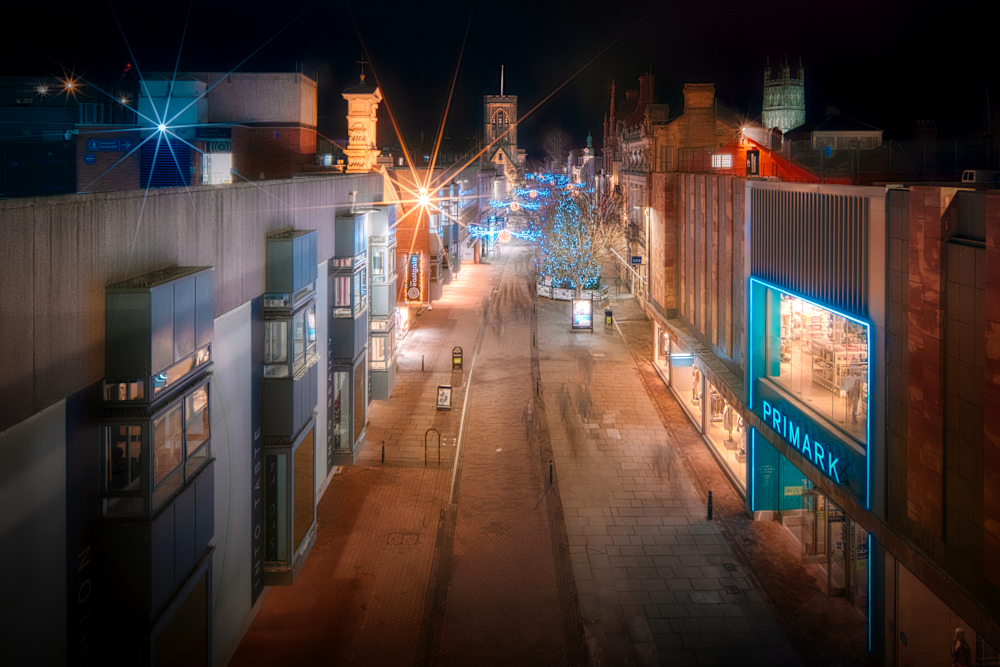
Eastgate Street was transformed by extensive 20th-century redevelopment. Large stores began to replace the historic buildings along the street in the inter-war period. The expansion of the Co-op store on the corner of Eastgate Street and Brunswick Road resulted in the demolition of densely packed terraced housing on Queen Street, amongst which was the birth-place of Gloucester composer and war-poet Ivor Gurney. St. Michael's Church was closed early in the Second World War and, due to a declining congregation, all but the tower demolished to make way for shops in 1956.
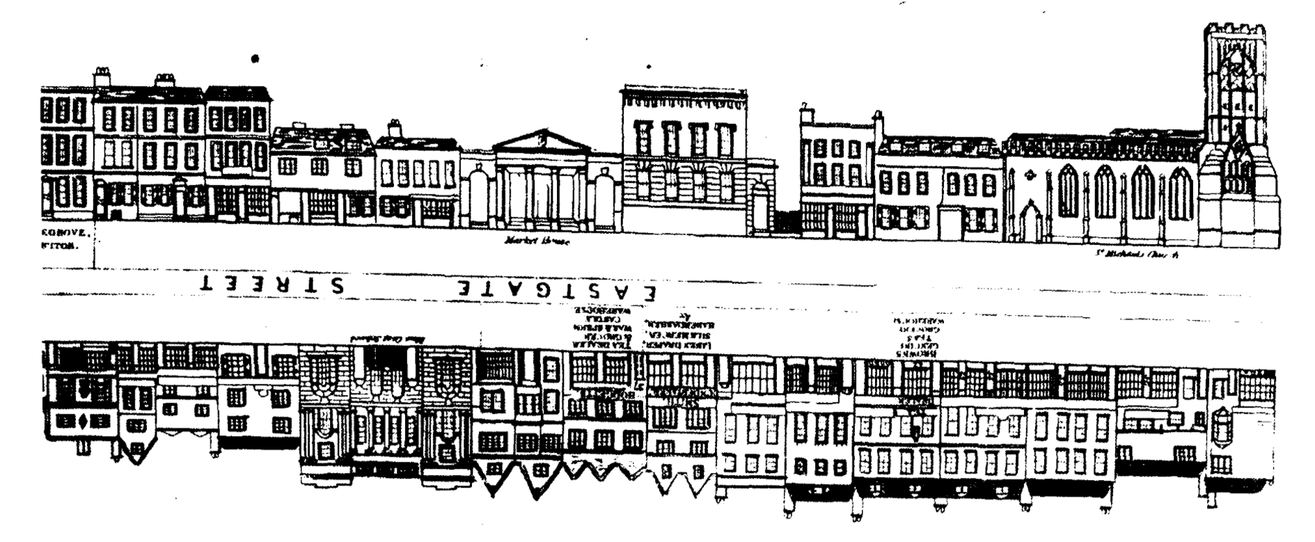
The upper Eastgate streetscape of 1841, the historic, individual, small-scale character of the architecture now lost to the uniform straight lines of large 20th-century buildings.
Between 1966 and 1974 the construction of the expansive new Eastgate Shopping Centre resulted in the demolition of a large part of the historic Eastgate Street area. The development replaced the 19th century market, transformed Queen Street into the covered passage of today's Queen's Way and replaced King Street, the other side of Eastgate Street to Queen Street, with King's Walk Shopping Centre. With the two new shopping centres the city acquired the larger, modern retail premises with service yards that would attract the big national retail chains.
Gloucester also gained a solution to the formidable rise in the number of vehicles that were already swamping its medieval streets. Rooftop car parking linked throughout the centre by bridges was a 60s innovation that massively increased the number of car parking spaces in the centre, from the 218 that were mostly located in King's Square to many thousands on the shopping centre roofs and multi-storey car parks behind. The need for flat roofing to accommodate parking was a significant factor in the transformation of the Eastgate Street frontage from small, traditional shops that reflected the centre's organic, unplanned evolution over centuries to the long, continuous horizontal lines of the modern streetscape. The medieval Bell Lane and narrow Dog Lane became access ramps to the rooftop car parks of, respectively, Eastgate Shopping Centre and King's Walk Shopping Centre.
Little of the street's historic character survives today. There are just six listed structures and four scheduled monuments between gate and The Cross, plus another three listed buildings nearby, compared to the twenty-seven listed sites along upper Westgate Street. On the south side, St. Michael's Tower is both a listed building and a scheduled monument and is operated as a tourist information point by the Gloucester Civic Trust, and the 19th-century Eastgate Market portico still stands as the entrance to Eastgate Shopping Centre, albeit relocated farther down the street from its original location during the construction of the centre.
On the north side of the street there is a cluster of four listed sites. The Guildhall remained a Council office until 1985, when the Council moved to offices in the Docks and the building was sold to the Cheltenham and Gloucester Building Society. It is today a branch of the TSB and home to the Gloucester Guildhall arts venue. Next door, the National Provincial Bank is now a branch of that bank's successor, Nat West. The red-stone Lloyds still stands, and its neighbour, no. 17, was originally built in the late-18th century as a shop and dwelling and is currently home to a branch of Body Shop.
City Wall Scheduled Monuments
The construction of Boots the Chemist on the site of the Co-op in 1980 gave the city a modern-day street-level view down onto the East Gate Bastion, the archaeological remains of the Roman wall, 11th-century east gate, 13th-century bastion and 16th-century horse pool set into the Roman ditch. It was, however, only won after a public campaign supported by the Citizen local newspaper against their destruction, and much of the archaeological remains of the Roman wall below on the rest of the site were still lost to a cellar. Tours of the viewing chamber by the Museum of Gloucester allow a closer view of ther bastion, including the remains of the Roman wall not visible from the street.
The East Gate Bastion is one of three scheduled monuments around the site of the east gate. The sites of two others lie on the other side of the street from the bastion, on the line of the Roman wall found at the east gate bastion. The first lies on the footprint of the former Nos. 47–49 Eastgate Street, a grade-II listed property built 1780 and known as Eastgate House. Its carved stone façade was lost to the demolition of the 1960s and replaced with the large shop that now stands between King's Walk and the former Primark on the corner of Eastgate Street and Clarence Street.
Before demolition, Eastgate House was the site of a printing works established in the 19th century by John Bellows. Born 1831, Bellows was a pioneer of archaeology in Gloucester. He was knowledgeable about the city's Roman origins, and in 1873, whilst extending his works into the garden behind Eastgate House, he dug a trial trench in search of evidence of the Roman wall. The remains he found are now preserved as the King's Bastion, excavated a century after Bellows's discovery, during the construction of the King's Walk shopping centre that did for his old print works. The bastion was closed by flooding in 2022, but it has been reported that tours will resume in 2025.
Nearby
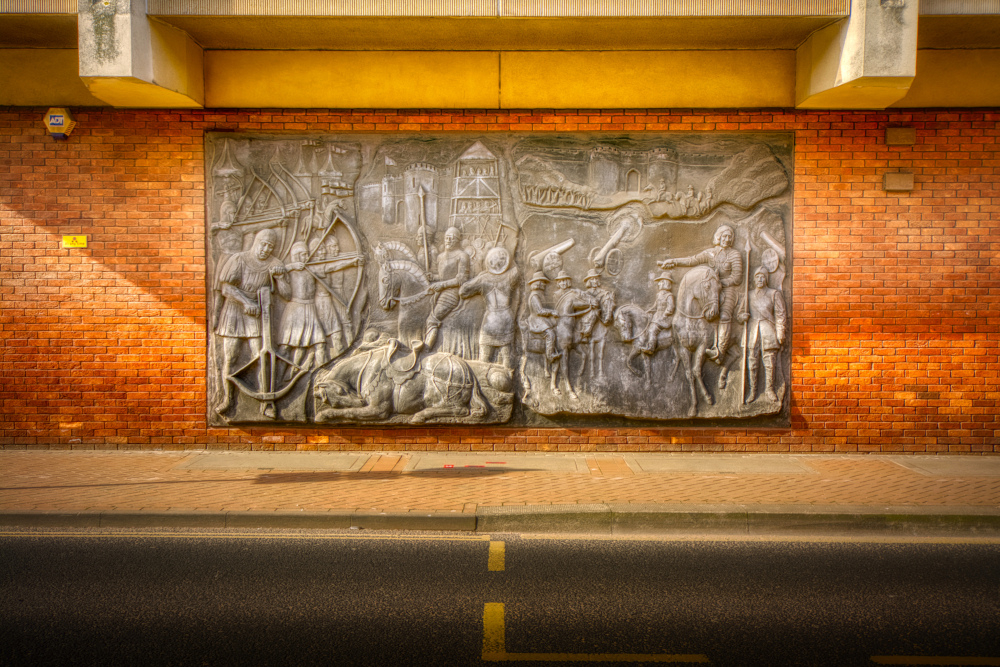
Artwork on Brunswick Road depicting two sieges of Gloucester, the first during the 13th-century Barons' War and the second during 17th-century English Civil War
At the far end of Queen's Way is all that survives of Bell Lane, which went by the name of Travel Lane in 1160 and was reduced to an access ramp into the Eastgate Shopping Centre car park in the 1960s. Next door stands Constitution House, recorded by Historic England as Winston Hall. Built c.1750, it belonged to the wealthy wool stapler Richard Chandler, whose fortune would have been somewhat dented by his investment in the failed initial construction of the Gloucester and Sharpness Canal at the end of the 18th century. The building was purchased by the local branch of the Conservative Party in 1883 and serves today as the Conservative Club.
Opposite Constitution House, on Brunswick Road, stands the Museum of Gloucester. Built in 1898, it initially served as a lecture hall for the Gloucester Science and Art Society before becoming a museum and art gallery in 1902. It stands on the line of the Roman wall, a section of which can be seen. Other exhibits include the 2,000-year-old Celtic Birdlip Mirror, the sword of Richard III, who granted Gloucester its town charter in 1483, and a small Roman figurine of Venus found during the construction of The Forum in 2021. Next door to the museum is the 1872-built Public Library, also initially serving the Gloucester Science and Art Society before being extended and converted to the library in the period 1897–1900.