Loading Images
Please bear with us...
Information
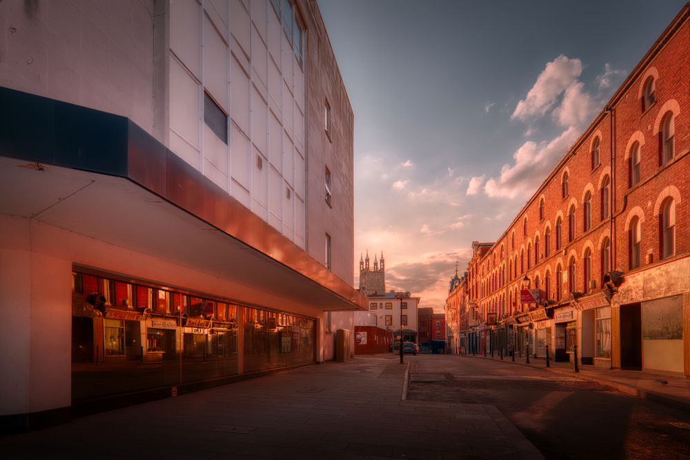
Northgate Street is one of the four original Roman streets in Gloucester. Whilst it is the truest of all four gate streets to its ancient form, the streetscape has been subject to much change down the centuries, leaving the street with relatively few buildings that have to date merited listing. Nine can be found along its length, plus another on a side street.
The street runs from The Cross in the city centre to the site of the Roman north gate, at the entrance to today's St. Aldate Street. In Roman times the north gate marked the start of Ermin Street, the main Roman road east out of Gloucester to Cirencester and on to London.
Medieval Period
Saxon St. Aldate Street lined with 19th-century terracing built on the line of the Roman Wall
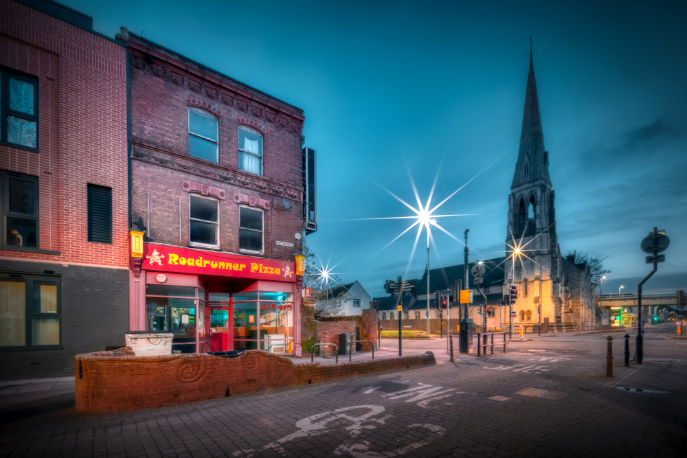
When the Saxons re-established Gloucester as a major settlement around the 10th century they extended Gloucester beyond the Roman walls. In the north this expansion brought the bottom of the London road within the town boundary. Known later as Lower Northgate Street, that stretch today is simply part of Northgate Street, which now ends at the junction with London Road on the inner ring road.
The Saxons created new streets around the skeleton provided by the four gate streets, all that had survived of the Roman street plan within Gloucester. Some of those Saxon streets survive to this day. St. Aldate Street is one such, running east from Northgate Street, just inside the site of the north gate along the line of the Roman wall. The construction from 1874 of the terrace on the north side (an unusually uniform stretch of pre-20th century architecture for central Gloucester and not yet listed) for furniture maker Edwin Lea unearthed remains of the Roman wall, as have other works along the street.
Hare Lane, which runs west from Northgate Street just outside the site of the Roman north gate and was until 1822 the main road north out of Gloucester, is another survivor of the Saxons' road building. In 1235 the lane was known as the tanners' street. The importance of the tanning industry then is marked today in a mosaic laid into the pavement on the corner of Northgate and St. Aldate, opposite the entrance to Hare Lane.
Site of the medieval outer north gate at the junction of Northgate Street and the modern inner ring road
In the medieval period the top end of Northgate Street was dominated by cordwainers – people who worked in the leather industry – and drapers, making this part of Northgate Street a busy commercial area second only to Westgate Street. Lower down, the street was the quarter of fullers – people who cleansed wool – and dyers, who took advantage of the Fullbrook, a man-made channel of the River Twyver that ran outside the north gate before passing through the Abbey (later Cathedral) precinct. By the 13th century the outer north gate at the end of Northgate Street – one of the ten gates of Gloucester – controlled entry into Gloucester from the north.
New Inn
By the middle of the 16th century the street boasted four important inns. Whilst names such as the Swan, the Bull and the Ram (an Abbey-owned inn recorded as being rebuilt in the period 1525–1544) have disappeared from Northgate Street, the New Inn survives as Northgate's only grade I building. The inn was another Abbey-owned enterprise, first built around 1430–1450, and has been described as Britain's finest example of a medieval galleried inn. Its pedigree did not spare it from the Georgian compulsion to re-front every Tudor-style property. In 1924 the current imitation timber-frame front was installed on the Northgate Street frontage and the northern corner restored to its original Tudor splendour. Some of the building's original features can also be appreciated along New Inn lane to the side of the property, a thoroughfare that pre-dates the building by several hundred years and was recorded c.1190 as Grant Lane. In a sea of imposters, charlatans and selective criteria, the New Inn has one of the most credible claims to be England's oldest pub in continuous use, trumped only by a slightly older pub in Somerset.
Somewhat less credible is the claim that the succession of Lady Jane Grey to the throne of England in 1553 was proclaimed at the New Inn, and specifically the implication that the monarch of England was decided in what was in the mid-16th century a provincial backwater. It would appear that the ill-fated Lady was in London at the time, and it seems likely that news of the proclamation in London spread to and was announced in towns and cities throughout the kingdom, in Gloucester's case at the New Inn which, after all, was a coaching inn at the city end of the London Road. Even more dubious is the claim often made that the proclamation in Gloucester was made by the 'Abbot of Gloucester'. There would have been abbots at the six monasteries that once existed in and around Gloucester, but no Abbot of Gloucester; Gloucester was a city, not a monastery. More than that, though, there were no abbots left in England at all following the dissolution of the monasteries by Lady Jane Grey's grand-uncle some fifteen years before her ill-fated proclamation.
St. John's Northgate
A contemporary of the New Inn is the tower of St. John's Northgate, added to an existing medieval church c.1450. Although there is a tradition of a Saxon church occupying this site from 931, the Church of St. John the Baptist, as it was originally known, dates from the 11th century. By the 18th century the church had become so dilapidated all but the tower was rebuilt, and the current structure dates to a 1734 rebuild.
Behind the church, St. John's Lane was known as Grace Lane in the late-13th century, though one source has it marked on a map of Saxon Gloucester. In its lower length as it approaches the junction with Northgate Street the lane follows the line of the once-walled Cathedral precinct boundary. From 1649 new houses began to replace the wall, and whilst none of those houses still stand, the early-19th century No. 17 St. John's Lane is now listed grade II. A small section of the precinct wall still stands in a corner of St. Lucy's Gardens outside the east entrance to the Cathedral precinct. Nearby stands the tip of the spire of St. John's, removed in 1910 after having become unsafe.
Between medieval spire and its relocated tip lies the site of the church graveyard, partially built over in the 1960s by today's Northgate Hall. Another graveyard located where the Regal Cinema (today a pub) was built 1956 on King's Square is marked on an 1852 map as St. John's burial ground and on subsequent maps as disused. In 1972 the Methodists shuttered their own church, which had been built 1878 next to the Northend Vaults a little farther down Northgate Street, and began sharing St. John's, resulting in the name change. In 1991 the front of the church facing Northgate Street was re-faced. The Anglican congregation, meanwhile, was dwindling, and in 1994 the church building was signed over to the Methodists.
Pubs
The Northend Vaults is an oasis of late-16th or early-17th century timber-framing, originally a merchant's house, sandwiched incongruously between oversized, brick-built shops of 1960s origin and dubious architectural merit (it was the construction of one of these, occupied today by Wilko, that brought the Methodist church building's brief existence to an end). Like most timber-framed buildings in Gloucester, the pub was re-fronted by the Georgians in the 18th century. Under Jellicoe's plan for the redevelopment of central Gloucester in the 1960s, the Northend Vaults was, like its non-conformist neighbour, scheduled to become rubble. However, the plan to extend Worcester Street through to Market Parade did not materialise, and the historic building lives on to soak up the spirits of those who pause there a while on their own journeys into history. The Imperial Inn a short distance up the road is a much younger building, having been built c.1890.
Georgian Transformations
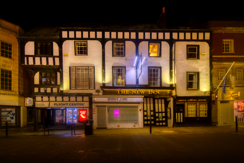
New Inn street front as restored in 1924 showing the impact of the Georgian affinity for brick, where the loss of all but one bay of jettied timber has been covered over with faux timber-framing.
Following the end of the English Civil War in the mid-17th century – during which Gloucester was a Parliamentarian stronghold – what was left of the Roman/medieval walls (only the eastern half still stood, from north gate round to south gate) was dismantled on the orders of a vengeful King Charles II. The King also removed from Gloucester control of the surrounding countryside (known as the inshire) granted to the city in 1483, thus ending a longstanding bone of contention between city and shire. As a result, Gloucester became an increasingly popular resort for the county gentry, who were catered for by specialist retail shops after the London fashion, the most fashionable of which were set up on Northgate and Westgate Streets.
In the Georgian period of the 18th century the appearance of Gloucester's streets was transformed by the replacement of timber-framing with more fashionable brick. Some old properties were completely replaced by new builds such as the terrace of three 18th-century townhouses at Nos. 6–10 just down from The Cross. Others were re-fronted, surviving examples of which (alongside the New Inn and the Northend Vaults) being the originally 16th-century merchant's house at No. 11 (the south-side neighbour of today's TK Maxx) and the somewhat neglected No. 62, originally a 15th-century merchant's house, opposite the entrance to Hare Lane.
Further transformation was effected by the Improvement Acts of the latter half of the 18th century. A 1750 act, intended to clear from the streets obstacles to the increasing amount of wheeled traffic, cleared from Northgate Street some historic buildings (unspecified in the source). In 1781 the last of the city's ancient and medieval defences disappeared with the dismantling of the city gates, including the north gate, the room above which had served as the city gaol, and outer north gate.
19th Century
Among the changes to the Northgate streetscape in the 19th century was the laying down in 1822 of Worcester Street to replace Hare Lane as the main road north out of the city. Development along the new street soon followed, with No. 1 continuing on round the corner as Nos. 83 & 85 Northgate Street. Another change that continues to make its mark on the Northgate streetscape was the construction in 1865 of the Spread Eagle Hotel at the bottom end of the street. The hotel closed in 1898, though the hotel's taproom continued to serve food and drink until it was demolished in the 1960s. The former hotel building was acquired by the Y.M.C.A., who renamed it Northgate Mansions. After a partial collapse, a wing of the building along Spread Eagle Road was pulled down in 2010. Although notable for its size and isolation, the surviving property is not listed, unlike No. 102, its early-19th century neighbour across Spread Eagle Road, which is listed grade II.
King's Square and The Oxbode
The Oxbode
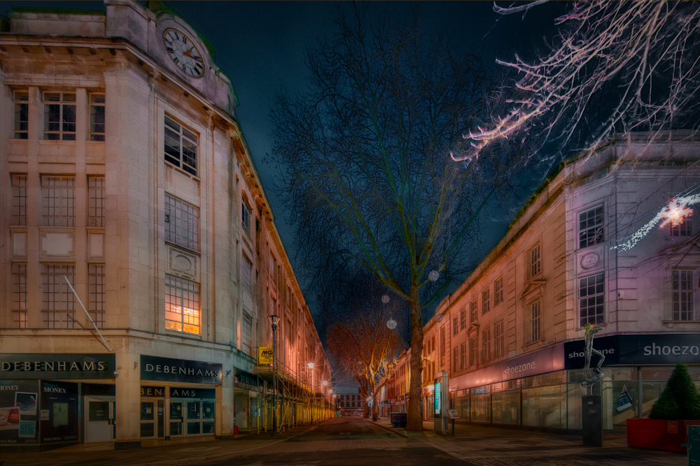
As Gloucester began a period of sustained population growth, the central area's evolution into a predominantly commercial centre by 1914 resulted in the city centre becoming increasingly depopulated. Its former residents moved (or were moved) to new suburbs, often as a result of slum clearances. A major clearance involved the crowded north-east quadrant within the lines of the former Roman/medieval walls, where old, sub-standard housing and shops were redeveloped into King's Square in the late-1920s and early 1930s.
In its first incarnation (of many, it seems), the square was a bus station and, until the 1960s, Gloucester's only dedicated car park. Oxbody Lane – first recorded in 1263 and, according to tradition, slightly less narrow at its entrance than an Ox is wide – was transformed into The Oxbode. The now much wider street was lined on its south side with new shops and on its north by the latest in retail trends, the large Bon Marché department store, later Debenhams and now a University of Gloucestershire campus.
The Bon was extended to face onto King's Square as part of the redevelopment of the 1960s and 1970s which saw the square transformed into an area of fountains set in concrete landscaping and a new pedestrian shopping precinct with roof-top car parking. The extension finally brought an end to the long story of the Church of St. Aldate and its graveyard which had previously occupied a plot on the south side of St. Aldate Street. That story may have begun before the Norman Conquest of 1066, though the first recorded mention of the church comes in 1205. The medieval church was demolished in 1655 and, 101 years later, a new church was built on the same site. In the 1930s that church was converted to a parish hall which, in 1963, was demolished and the site, including the former graveyard, converted into the service yard of the newly enlarged Bon Marché.
Later 20th Century
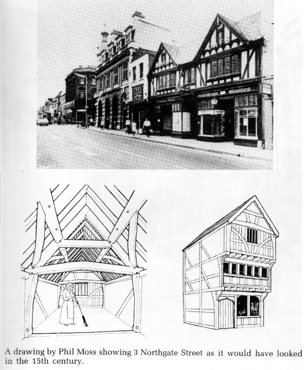
Fake timber-framed, 1936-built Lawrence Bros. bakery and, next to it, the small, white-rendered, genuinely historic, 15th-century No. 3, with illustrations of its original form before 18th-century re-fronting in brick obscured its true heritage.
It was towards the end of this period of comprehensive redevelopment in the city centre that the somewhat cavalier attitude to the city's heritage began to change, though too slowly to save some important historic treasures. In 1971 work was underway on redeveloping No. 4 Westgate Street as an extension to the c.1907-vintage bank on the corner of Westgate and Northgate. As a crane was lifting out the remains of a Roman column that had been found, a watching archaeologist wandered into No. 3 Northgate Street, vacated in advance of its own imminent redevelopment, which backed onto the construction site. There he discovered historical gold.
Whilst from the front No. 3 looked to be a small, rather unremarkable little shop, it turns out that was thanks only to the Georgians and their preference for re-fronting timber-framed properties with brick in the 18th century. The building, until recently occupied by Southern's Store, was in fact a late-15th century property with a significant portion of its original timber-frame construction still intact.
Despite the concerted efforts of members of the Gloucester and District Archaeological Group and a campaign for preservation championed by The Citizen local newspaper, it was too late to save the building. The redevelopment of it and its neighbour (a building previously occupied by Lawrence Bros. Bakery that looked for all the world to be a centuries old timber-framed property but was actually not even four decades old) went ahead. The loss was the catalyst for the establishment in 1972 of the Gloucester Civic Trust, a charitable organisation run by volunteers to preserve and promote the city's heritage.
It was, however, only the beginning of a change in attitudes that would see the Civic Trust restore historic buildings and, more recently, take on the Folk of Gloucester, and result in enormous effort being put in to recording and preserving the archaeological remains beneath yet another redevelopment of the King's Quarter.
In Jellicoe's plan of the 1960s, the buildings on the western side of Northgate Street opposite the entrance to St. Aldate Street were to be cleared to open up a view of the Cathedral. Those properties were instead redeveloped. It was during this construction in 1974 that the foundations of the Roman north gate were uncovered. Unlike the archaeological remains of the east gate, also unearthed around this time and saved from destruction by a public campaign, the north gate remains were ripped out from where they had lain buried for nearly two millennia. Some of the stone blocks removed can be seen today tucked under the display shelf in the Longfield charity shop on the ground floor of the new building.
Historic Gloucester: An Illustrated Guide to the City and its Buildings
Gloucester: Recreating the Past
A Comprehensive Plan for the Central Area of the City of Gloucester
General Development: Central Area 1961–1975